Thursday, December 30, 2010
Tabulet for everyone
The presence of a variety of platforms based Android operating system since some time ago to attract enough high in world markets, including Indonesia. Welcoming the market share, recently we can see the presence of Android-based tablets had a local brand that comes from local ideas Tabulet named.Products tablet combines the process of some countries, namely: hardware that comes from Korea
Monday, December 27, 2010
Ubuntu Linux Powered Tablet On The Way
Although some Linux tablets have already made their way to the market over the past couple of months, Ubuntu has been notably absent from the landscape, but it would seem that things are about to change in the near future, a tablet powered by the famous open-source operating system being already in the works.Although, at some point, we'd thought that 2010 was not going to be the year of the
Friday, December 24, 2010
Dashing through the snow... with NORAD and Google
(Cross-posted from the Official Google Blog and Lat Long Blog)
Every Christmas Eve, children all over the world ask themselves—and their parents—questions about Santa’s magical journey. How does Santa visit so many children in one night? Will he eat the cookies I left out? How does he fit all those presents into his sleigh? These childhood mysteries are part of what makes the Santa tradition so special.
There’s one timeless question that we’re proud to say we can help answer: Where in the world is Santa at this very moment? Thanks in part to recent advances in warp-speed GPS technology and some very clever elves (elveneering?) NORAD Tracks Santa is once again prepped and ready to go.
Starting tomorrow, December 24 at 2:00am EST, visit www.noradsanta.org to follow Santa as he journeys around the world delivering presents to children in more than 200 countries and territories. There are a few different ways to find the jolly old man in his unmistakable red suit over the course of the day, so feel free to track him using any of the following methods:
NORAD (North American Aerospace Defence Command) first began to track Santa in 1955 when a misprinted advertisement in a Sears & Roebuck catalogue mistakenly led callers expecting a Santa-hotline to the NORAD commander-in-chief's telephone. Embracing the spirit of the season, NORAD used its satellite and radar capabilities to offer callers sleigh-location updates, and has tracked Santa's whereabouts on Christmas Eve ever since. Then in 2004, Google started tracking Santa on Google Earth as a 20% project, which in 2007 grew into a partnership with NORAD, adding the mapping technology of Google Maps and Google Earth to the NORAD experience. Over the years, other Google teams have also joined in the holiday fun (YouTube, Google Voice’s www.SendACallFromSanta.com and Google SketchUp).
As we approach this year’s Christmas Eve adventure, Santa was able to take a break from the preparations to visit the New York Stock Exchange this past Monday. His helpful elves kept everything at the North Pole on schedule while folks from Google and NORAD attended the Closing Bell ceremony, and stood alongside Santa from Macy’s going over last minute details about tomorrow’s big ride.

So don’t forget to visit www.noradsanta.org tomorrow morning starting at 2:00am EST when Santa embarks on his flight. From all of us here at Google, happy holidays and here’s to a very happy New Year!

Every Christmas Eve, children all over the world ask themselves—and their parents—questions about Santa’s magical journey. How does Santa visit so many children in one night? Will he eat the cookies I left out? How does he fit all those presents into his sleigh? These childhood mysteries are part of what makes the Santa tradition so special.
There’s one timeless question that we’re proud to say we can help answer: Where in the world is Santa at this very moment? Thanks in part to recent advances in warp-speed GPS technology and some very clever elves (elveneering?) NORAD Tracks Santa is once again prepped and ready to go.
Starting tomorrow, December 24 at 2:00am EST, visit www.noradsanta.org to follow Santa as he journeys around the world delivering presents to children in more than 200 countries and territories. There are a few different ways to find the jolly old man in his unmistakable red suit over the course of the day, so feel free to track him using any of the following methods:
- See Santa on a Google Map: On your home computer or laptop, visit www.noradsanta.org and choose your preferred language. You’ll see a large Google Map on the page displaying Santa’s current location and his next stop. Click the video icons to watch “Santa Cam” videos, and click the gift icons to learn more about each city.
- Watch Santa fly with the Google Earth Plug-in: From www.noradsanta.org, click on the link Track Santa in Google Earth. You'll see Santa steering his sleigh right on the webpage. If you don't have the Google Earth plug-in, you can get ready by downloading it ahead of time.
- Follow Santa on your phone: Track Santa from your mobile phone by opening Google Maps for mobile and searching for [santa]. Or, visit m.noradsanta.org on your phone’s browser.
- Subscribe to his YouTube channel: Santa’s home on YouTube is at http://www.youtube.com/noradtrackssanta. That’s where you can find videos from his journey throughout the night.
- Get real-time information about Santa’s location: Use Google’s Realtime Search to get updates from social networks, news and micro-blogs like Twitter at @noradsanta, and keep up with news about his journey on this Facebook page.
NORAD (North American Aerospace Defence Command) first began to track Santa in 1955 when a misprinted advertisement in a Sears & Roebuck catalogue mistakenly led callers expecting a Santa-hotline to the NORAD commander-in-chief's telephone. Embracing the spirit of the season, NORAD used its satellite and radar capabilities to offer callers sleigh-location updates, and has tracked Santa's whereabouts on Christmas Eve ever since. Then in 2004, Google started tracking Santa on Google Earth as a 20% project, which in 2007 grew into a partnership with NORAD, adding the mapping technology of Google Maps and Google Earth to the NORAD experience. Over the years, other Google teams have also joined in the holiday fun (YouTube, Google Voice’s www.SendACallFromSanta.com and Google SketchUp).
As we approach this year’s Christmas Eve adventure, Santa was able to take a break from the preparations to visit the New York Stock Exchange this past Monday. His helpful elves kept everything at the North Pole on schedule while folks from Google and NORAD attended the Closing Bell ceremony, and stood alongside Santa from Macy’s going over last minute details about tomorrow’s big ride.

Santa with NORAD, Google and members of the Marine Toys for Tots Foundation (that’s me, the tall guy in the back row clapping)
So don’t forget to visit www.noradsanta.org tomorrow morning starting at 2:00am EST when Santa embarks on his flight. From all of us here at Google, happy holidays and here’s to a very happy New Year!

Thursday, December 23, 2010
Android In Spaaaace!
Here at Google, we’re all about exploration. It’s no surprise that some of our favorite products are built to let you explore the world in ways never before possible. Google Maps lets you find your way all around the world. Google Earth lets you explore the planet in detail, complete with trees and oceans. And Google Sky Map lets you explore the skies right from your Android device. Well, we wanted to do a little exploring of our own, so we decided to venture into near space, with the help of some Androids.
Recently, we travelled to Ione, CA and sent seven payloads up, up, and away into near space, each equipped with a Nexus S. We took some cues from others who have sent homemade weather balloon rigs far up, and we wanted an opportunity to collect some interesting data about the sensors in Nexus S – GPS, gyroscope, accelerometer, and magnetometer. We also couldn’t resist what looked like a great way to spend a weekend. Sending the balloons up also gave us an opportunity to capture some stunning imagery and videos of Earth. Take a look at unaltered footage of an Android at over 100,000 ft above the Earth’s surface:
The Rig
How did we get our little Android commanders that high up? Well, first the Android platform provides a robust development environment and Nexus S has a great set of embedded sensors, both of which made it easy for us to write the apps we needed for this project. Going forward with other similar projects we have an open environment that we can modify at any level necessary. We then worked with UCSC student Greg Klein to prepare each of the payloads, which were housed in foam coolers. We secured a nylon load line to the cooler and attached to it a radar reflector, a parachute, and finally, a weather balloon. Every payload had an APRS transmitter attached to a GPS that was known to work at high altitudes, as well as batteries for power. The remainder of each payload was different for each balloon: some had digital cameras taking pictures and some had video cameras mounted at various angles (up, down, and at the horizon).
These phones were running a variety of apps: Google Maps for Mobile 5.0 (with offline map data) which allowed us to see what was directly below the balloon, Google Sky Map to see if we could identify the real stars in the backdrop, Latitude to report location when the phones had a data connection, and our own custom sensor logging app that sampled all the available sensors on the device. We even manned our payloads with some special astronauts: small Android robots, and boy did they fly. Check out an in-depth look at how we prepared and launched the payloads:
What We Found
The payloads collected a lot of data, and many reached high altitudes, with the highest topping out at 107,375 ft., over 20 miles high, or over three times the height of an average commercial jet. We also clocked one of the payloads at 139 mph at its fastest.
In tracking the sensors on each of the phones, we observed that the GPS in Nexus S could function up to altitudes of about 60,000 ft. and would actually start working again on the balloon’s descent. We also saw that Nexus S could withstand some pretty harsh temperatures (as low as -50˚C). Some interesting data we collected:
Maximum Speed: 139 mph
Maximum Altitude: 107,375 ft (over 20 miles, over 30 km)
Maximum Ascent Rate: 5.44 m/s
Average Flight Duration: 2 hours, 40 minutes
Average Descent Time: 34 minutes
By analyzing all the collected data, we were able to find some interesting trends. For instance, we determined the speed and altitude of the jet stream: about 130mph at 35,000 ft.
In the end, the team recovered all of the payloads sent up, we even recovered the payload we sent as a test a week prior to the actual launch. We had a blast taking Android all the way up to near space. If you're interested in launching a balloon of your own, click here for more info. We have more exciting things coming your way as we use the openness of the Android platform to experiment here at mission Android headquarters.
*Special thanks to Arshan Poursohi, Greg Klein, and Tommy Nourse for all their help.
Posted by Zi Wang, Captain, Mission Android Headquarters
Tuesday, December 21, 2010
Epson L100 and L200 Original CISS Printer
PT Epson Indonesia has launched a single-function printers, known under the name Epson L100 and printer all-in-one Epson L200. Both new printer products are designed specifically for the Indonesian market with features Continues Epson Original Ink Tanks system that can improve productivity and save on printing costs for users of home-based classes to business users who need a cheap CISS
Saturday, December 18, 2010
Under the hood of Google Maps 5.0 for Android
(Cross-posted from the Official Google Blog)
Yesterday we introduced Google Maps 5.0 for Android with two significant new features: 3D interaction and offline reliability. In order to create these features, we rebuilt Maps using vector graphics to dynamically draw the map as you use it. Building a vector graphics engine capable of achieving the visual quality and performance level you expect from Google Maps was a major technical challenge and enables all sorts of future possibilities. So we wanted to give you a closer look under the hood at the technology driving the next generation of mobile maps.
Vector graphics
Before diving into how Maps uses vector graphics, it may be helpful to understand how maps were created before. Previously, Google Maps downloaded the map as sets of individual 256x256 pixel “image tiles.” Each pre-rendered image tile was downloaded with its own section of map imagery, roads, labels and other features baked right in. Google Maps would download each tile as you needed it and then stitch sets together to form the map you see. It takes more than 360 billion tiles to cover the whole world at 20 zoom levels!
Now, we use vector graphics to dynamically draw the map. Maps will download “vector tiles” that describe the underlying geometry of the map. You can think of them as the blueprints needed to draw a map, instead of static map images. Because you only need to download the blueprints, the amount of data needed to draw maps from vector tiles is drastically less than when downloading pre-rendered image tiles. Google Maps isn’t the first mobile app to use vector graphics—in fact, Google Earth and our Navigation (Beta) feature do already. But a combination of modern device hardware and innovative engineering allow us to stream vector tiles efficiently and render them smoothly, while maintaining the speed and readability we require in Google Maps. Just try it out and see for yourself!
One map, many perspectives
Using vector tiles instead of image tiles gives Maps the flexibility to re-draw the same map from different perspectives using the same set of data. Zooming is one example of this at work. If you magnify an map image tile by 2x, lines such as roads and text would get twice as wide and appear blurry. As a result, we had to constrain Maps to 20 fixed “zoom levels,” each one twice as close as the last. Every time you zoomed in further, you’d need to download a completely new set of image tiles. It took time to load new data over a mobile data connection, and would fail when you lost your connection in a subway or large building.


With vector graphics, you no longer need to “round” to the nearest zoom level and then download all the tiles for that level. One vector tile has the underlying vector data (or blueprints) to draw the map at many different levels of scale. So when you zoom, the map stops when your fingers stop, and roads and labels always stay crisp. This same technique powers the new 3D map interactions: tilt, rotate and compass mode. Just like with zooming, Maps uses the same vector data to draw the map from any angle or direction as you tilt or rotate.
We can also display entirely new levels of detail that weren’t possible with flat image tiles. For example, in the 100+ cities where we have 3D building data, each building is drawn in 3D using a polygonal building footprint and heights for different parts of the building. And with tilt and rotate, you can see them from a variety of different angles.
Reading the map
Just like other map features, labels are dynamically drawn so they continue to face you and stay legible if you rotate the rest of the map or use compass mode. Maps also “chooses” the best labels to show you based on several factors. You’ll notice labels fade in and out as you interact with the map so that the most useful ones appear and the map never gets too cluttered.


Vector graphics also allow us to draw additional data on the map more clearly. For example, traffic or transit lines no longer block the labels beneath them. We can also draw the same map in different styles — like “satellite view” where the roads are translucent over aerial imagery, or Navigation’s “night mode” where a darker palette helps your eyes adjust quickly in the lower light.


Offline reliability
Vector graphics also enable another significant new feature: the ability to continue viewing maps even when you have poor—or no—network connections. Because each vector tile works across multiple zoom levels, it requires more than 100 times less data to view maps across all zoom levels than before, allowing Maps to cache much larger areas of the map on your device.
With this first version, Maps proactively caches map data for the places you use Maps the most—where you’re actively using it as well as places for which you search or get directions. Then when you’re plugged in and connected over WiFi, caching happens automatically. Near your frequent places, you’ll get detailed vector tiles for city-sized regions so you can see every road labeled. Further away, you’ll have less detail but will typically have towns and highways labeled for miles. We’re continuing to work on these algorithms, so you’ll see improvements over time.
Offline rerouting
With Google Maps Navigation (Beta), you’ll also see the benefits of additional caching with offline rerouting. This feature is only possible because Navigation caches not only map data but also data like turn restrictions for the areas surrounding your route. You’ll still need to be connected when you first start a trip to download and cache your route. But this way, even if you take a wrong turn after losing your connection, Navigation can use the cached data to get you back on your way. We will be rolling this feature out gradually over the next few weeks.
This is just the start, and we’re really excited about all the possible ways to use vector graphics technology for the next generation of Google Maps. So please stay tuned!
Update (12:47pm PST): Tweaked the description of the difference between image maps zoom levels.
Yesterday we introduced Google Maps 5.0 for Android with two significant new features: 3D interaction and offline reliability. In order to create these features, we rebuilt Maps using vector graphics to dynamically draw the map as you use it. Building a vector graphics engine capable of achieving the visual quality and performance level you expect from Google Maps was a major technical challenge and enables all sorts of future possibilities. So we wanted to give you a closer look under the hood at the technology driving the next generation of mobile maps.
Vector graphics
Before diving into how Maps uses vector graphics, it may be helpful to understand how maps were created before. Previously, Google Maps downloaded the map as sets of individual 256x256 pixel “image tiles.” Each pre-rendered image tile was downloaded with its own section of map imagery, roads, labels and other features baked right in. Google Maps would download each tile as you needed it and then stitch sets together to form the map you see. It takes more than 360 billion tiles to cover the whole world at 20 zoom levels!
Now, we use vector graphics to dynamically draw the map. Maps will download “vector tiles” that describe the underlying geometry of the map. You can think of them as the blueprints needed to draw a map, instead of static map images. Because you only need to download the blueprints, the amount of data needed to draw maps from vector tiles is drastically less than when downloading pre-rendered image tiles. Google Maps isn’t the first mobile app to use vector graphics—in fact, Google Earth and our Navigation (Beta) feature do already. But a combination of modern device hardware and innovative engineering allow us to stream vector tiles efficiently and render them smoothly, while maintaining the speed and readability we require in Google Maps. Just try it out and see for yourself!

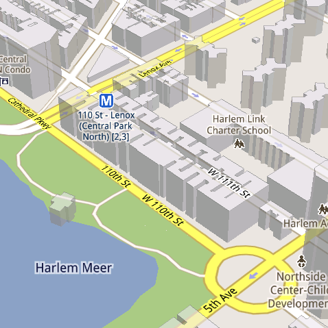
See the difference between image tiles (left) and vector tiles (right) tilted to show 3D buildings.
One map, many perspectives
Using vector tiles instead of image tiles gives Maps the flexibility to re-draw the same map from different perspectives using the same set of data. Zooming is one example of this at work. If you magnify an map image tile by 2x, lines such as roads and text would get twice as wide and appear blurry. As a result, we had to constrain Maps to 20 fixed “zoom levels,” each one twice as close as the last. Every time you zoomed in further, you’d need to download a completely new set of image tiles. It took time to load new data over a mobile data connection, and would fail when you lost your connection in a subway or large building.


Compared to image tiles (left), vector tiles (right) keep lines and labels crisp as you zoom.
We can also display entirely new levels of detail that weren’t possible with flat image tiles. For example, in the 100+ cities where we have 3D building data, each building is drawn in 3D using a polygonal building footprint and heights for different parts of the building. And with tilt and rotate, you can see them from a variety of different angles.
Reading the map
Just like other map features, labels are dynamically drawn so they continue to face you and stay legible if you rotate the rest of the map or use compass mode. Maps also “chooses” the best labels to show you based on several factors. You’ll notice labels fade in and out as you interact with the map so that the most useful ones appear and the map never gets too cluttered.


See the difference between rotating maps with static labels (left) and dynamic labels (right).


Previously, map features like labels and traffic could conflict (left) instead of blend seamlessly (right).
Offline reliability
Vector graphics also enable another significant new feature: the ability to continue viewing maps even when you have poor—or no—network connections. Because each vector tile works across multiple zoom levels, it requires more than 100 times less data to view maps across all zoom levels than before, allowing Maps to cache much larger areas of the map on your device.
With this first version, Maps proactively caches map data for the places you use Maps the most—where you’re actively using it as well as places for which you search or get directions. Then when you’re plugged in and connected over WiFi, caching happens automatically. Near your frequent places, you’ll get detailed vector tiles for city-sized regions so you can see every road labeled. Further away, you’ll have less detail but will typically have towns and highways labeled for miles. We’re continuing to work on these algorithms, so you’ll see improvements over time.
Offline rerouting
With Google Maps Navigation (Beta), you’ll also see the benefits of additional caching with offline rerouting. This feature is only possible because Navigation caches not only map data but also data like turn restrictions for the areas surrounding your route. You’ll still need to be connected when you first start a trip to download and cache your route. But this way, even if you take a wrong turn after losing your connection, Navigation can use the cached data to get you back on your way. We will be rolling this feature out gradually over the next few weeks.
This is just the start, and we’re really excited about all the possible ways to use vector graphics technology for the next generation of Google Maps. So please stay tuned!
Update (12:47pm PST): Tweaked the description of the difference between image maps zoom levels.
Friday, December 17, 2010
The next generation of mobile maps
(Cross-posted from the Official Google Blog and the Google Lat Long Blog)
Update (12/17/2010 11:30am PST): Check out a related post on the technology powering Google Maps 5.0 for Android.
I’m excited to announce Google Maps 5.0 for Android, with two significant new features: 3D interaction and offline reliability.
We launched Google Maps for mobile a little more than five years ago. Since then, we’ve added dozens of features, and we’ve grown from a few thousand to more than 100 million users. Still, a couple of things have remained the same: a flat, north-up map and the need for a strong Internet connection. Today, we’re changing that for the first time.


Explore maps in 3D
Until now, Google Maps has always downloaded the map as a set of small, square images that we stitch together to form the map you see. (You’ve probably seen those gray squares getting filled in, block-by-block, as the images load over the network.) Starting today, we’ll use vector graphics to dynamically draw the map on your device as you use it, allowing you to interact with it in new ways:
Offline reliability
Google Maps has always been, and continues to be, a fundamentally Internet-connected experience, meaning you always get the freshest map and place data, search and voice search, live traffic conditions, satellite and Street View imagery, and much more. Still, we understand that mobile Internet connections aren’t 100% reliable. So today we’re happy to take the first steps toward greater offline reliability, so you can find your way even if you lose your connection.
In the past, you’ve probably had frustrating moments when you get stranded without a map, whether ducking into the subway, sitting at the back of a restaurant or traveling anywhere with a flaky Internet connection. But dynamically drawing maps requires 100 times less data to get maps across all zoom levels, so now we’re able to proactively cache (or store) large areas on your device based on where you use Maps the most. This way, you can rely on having fast, robust maps available to you where you’re most likely to need them.
For example, I live in San Francisco and work in Mountain View, so Maps makes sure I can always pull up detailed street maps of each city and area maps for the whole San Francisco Bay Area. When I do have an Internet connection, I still get live traffic, imagery, richer map details and all the other features I’m used to with Google Maps.
Rather than having a static set of maps when installed, Maps will automatically start caching the areas you visit the most when your device is plugged in and connected to WiFi (e.g., the nightly charge). We’re already hard at work improving the algorithms and technology behind these features, so over time you can expect to see maps work better in more offline situations.
Offline rerouting
If you’re one of the more than 10 million people relying on Google Maps Navigation (Beta), our free turn-by-turn GPS navigation feature, losing your Internet connection can be particularly painful. (This happened to me on a recent ski trip to Tahoe, and I was left trying to manually find my way back to my route.) So we’re also introducing offline rerouting. You’ll still need a connection to start a route, but if you miss a turn along the way, we’ll quickly get you back on track, even if you don’t have an Internet connection. We’ll be rolling this feature out gradually over the next few weeks.

These new features are just the first steps in maximizing dynamic map drawing technology to create a faster, more interactive experience where efficiency really matters: mobile devices. For example, we estimate that viewing maps now requires almost 70% less mobile network data overall than before. We can’t wait to take the next steps in making Google Maps faster, more reliable and even more useful no matter where you take it.
Get Google Maps for mobile 5.0 by searching for Google Maps in Android Market (or tap on this link if you’re on your phone). Android 1.6+ devices can get Maps 5.0, but 3D and offline features require Android 2.0+, and some features may not be supported for all devices or countries.
So try it out. Wander around in compass mode, explore 3D buildings—even dare to open Maps on the subway! I hope you enjoy all the new features as much as we do.
Update (12/17/2010 11:30am PST): Check out a related post on the technology powering Google Maps 5.0 for Android.
I’m excited to announce Google Maps 5.0 for Android, with two significant new features: 3D interaction and offline reliability.
We launched Google Maps for mobile a little more than five years ago. Since then, we’ve added dozens of features, and we’ve grown from a few thousand to more than 100 million users. Still, a couple of things have remained the same: a flat, north-up map and the need for a strong Internet connection. Today, we’re changing that for the first time.


Tilt while zoomed in (left) or use compass mode (right) to orient yourself with 3D buildings.
Explore maps in 3D
Until now, Google Maps has always downloaded the map as a set of small, square images that we stitch together to form the map you see. (You’ve probably seen those gray squares getting filled in, block-by-block, as the images load over the network.) Starting today, we’ll use vector graphics to dynamically draw the map on your device as you use it, allowing you to interact with it in new ways:
- Tilting: Drag down with two fingers to tilt the map. Tilt while zoomed in on one of the 100+ cities around the world with 3D buildings to see a skyline spring to life.
- Rotating: Twist with two fingers to rotate the map. After tilting to see 3D buildings, rotate around them to gain a new perspective from any direction.
- Smooth zooming: Slide two fingers together or apart, and see the map and labels continuously scale to any zoom level, stopping when your fingers stop.
- Compass mode: Center the map on your location, and then tap the compass button in the top right corner. The map will flip into 3D mode and start rotating to match your perspective, while still keeping all the labels upright and readable.
Offline reliability
Google Maps has always been, and continues to be, a fundamentally Internet-connected experience, meaning you always get the freshest map and place data, search and voice search, live traffic conditions, satellite and Street View imagery, and much more. Still, we understand that mobile Internet connections aren’t 100% reliable. So today we’re happy to take the first steps toward greater offline reliability, so you can find your way even if you lose your connection.
In the past, you’ve probably had frustrating moments when you get stranded without a map, whether ducking into the subway, sitting at the back of a restaurant or traveling anywhere with a flaky Internet connection. But dynamically drawing maps requires 100 times less data to get maps across all zoom levels, so now we’re able to proactively cache (or store) large areas on your device based on where you use Maps the most. This way, you can rely on having fast, robust maps available to you where you’re most likely to need them.
For example, I live in San Francisco and work in Mountain View, so Maps makes sure I can always pull up detailed street maps of each city and area maps for the whole San Francisco Bay Area. When I do have an Internet connection, I still get live traffic, imagery, richer map details and all the other features I’m used to with Google Maps.
Rather than having a static set of maps when installed, Maps will automatically start caching the areas you visit the most when your device is plugged in and connected to WiFi (e.g., the nightly charge). We’re already hard at work improving the algorithms and technology behind these features, so over time you can expect to see maps work better in more offline situations.
Offline rerouting
If you’re one of the more than 10 million people relying on Google Maps Navigation (Beta), our free turn-by-turn GPS navigation feature, losing your Internet connection can be particularly painful. (This happened to me on a recent ski trip to Tahoe, and I was left trying to manually find my way back to my route.) So we’re also introducing offline rerouting. You’ll still need a connection to start a route, but if you miss a turn along the way, we’ll quickly get you back on track, even if you don’t have an Internet connection. We’ll be rolling this feature out gradually over the next few weeks.
Google Maps Navigation now automatically reroutes you, even if you lose your connection.
These new features are just the first steps in maximizing dynamic map drawing technology to create a faster, more interactive experience where efficiency really matters: mobile devices. For example, we estimate that viewing maps now requires almost 70% less mobile network data overall than before. We can’t wait to take the next steps in making Google Maps faster, more reliable and even more useful no matter where you take it.
Get Google Maps for mobile 5.0 by searching for Google Maps in Android Market (or tap on this link if you’re on your phone). Android 1.6+ devices can get Maps 5.0, but 3D and offline features require Android 2.0+, and some features may not be supported for all devices or countries.
So try it out. Wander around in compass mode, explore 3D buildings—even dare to open Maps on the subway! I hope you enjoy all the new features as much as we do.
Thursday, December 16, 2010
The wait is over: Announcing Nexus S availability in the U.S.
Last week we announced Nexus S, a pure Google phone. With a brilliant 4” Contour Display, a 1GHz Hummingbird processor, the latest Google mobile apps and Android 2.3 (Gingerbread) pre-installed, we’re excited about getting this great device out there.
We’re pleased to announce that starting today, this phone will be available for sale through Best Buy and Best Buy Mobile stores across the U.S. and online. The phone is sold unlocked and can be bought for $529.99 without a service plan or for $199.99 with a T-Mobile service plan.
Can't make it to a store? Order online now through Best Buy. By the way, some of our old friends also can’t wait to get their hands on a Nexus S!
Update Dec 16 10:52am PST: Looking to purchase a no-contract Nexus S from Best Buy? Look no further.
Posted by Kenzo Fong Hing, Product Marketing Manager
Wednesday, December 15, 2010
Voice Search gets personal
When we launched Voice Search more than two years ago, we wanted it to “just work” right out of the box, without an initial setup process. And so, we built speech models broad enough to accommodate a wide variety of people, regardless of gender, age, and accents, or variations in pitch, pace, and other factors. But we always knew we could build a more accurate model by listening to your voice, and learning how you -- as a unique individual -- speak. So today we’re launching personalized recognition.

If you opt into personalized recognition, we begin to associate the recordings of the words that you ask us to recognize with your Google account. We then automatically use these words to build a speech model specifically for you. This speech model enables us to deliver greater recognition accuracy. Although subtle, accuracy improvements begin fairly quickly and will build over time.
The first time you use Voice Search, you’ll be presented with a dialog to turn on personalized recognition. Google takes your privacy seriously, so you can enable or disable personalized recognition at any time through the Google voice recognition settings on your phone. If you’d like to disassociate your voice recordings from your Google Account, you can do so through the Google Dashboard in the Speech section.
The personalized recognition functionality is currently available for English in the United States. We plan to support other countries and languages in the near future. To enable it, you must have Android 2.2 or higher, and download the latest version of the Voice Search app from Android Market. The new app also includes some improvements to name recognition and speed, especially over 3G and EDGE connections.
So go ahead and download the latest Voice Search app, and let’s get personal!

Posted by Amir Mané, Product Manager and Glen Shires, Member of Technical Staff
Tuesday, December 14, 2010
Google Voice app now supports iPad & iPod Touch
(cross-posted from the Google Voice Blog)
Since we launched Google Voice for iPhone a few weeks ago, we’ve been hard at work to add a few improvements that didn’t make it into the first release.
At the top of the list was adding support for iPod Touch and iPad. Starting today, you can download a new version of Google Voice that lets you use all the features of the app on these devices, such as sending and receiving free text messages - except, of course, make cellular calls.
While you can’t use your iPod or iPad as a phone, you can use it to initiate Google Voice calls with your phones. We call this feature Click2Call. Simply click any ‘Call’ button in the Google Voice app on your iPod or iPad and then select which of your phones you want to ring. Google Voice will call your phone and then connect your call.

While we were at it, we also made a few other improvements to the app:
The Google Voice app is available to download from the Apple App Store today. You’ll need an iPhone, iPad, or iPod Touch with iOS 3.1 or later and a valid Google Voice account to use the app. At this time, Google Voice is available in the U.S. only.
Since we launched Google Voice for iPhone a few weeks ago, we’ve been hard at work to add a few improvements that didn’t make it into the first release.
At the top of the list was adding support for iPod Touch and iPad. Starting today, you can download a new version of Google Voice that lets you use all the features of the app on these devices, such as sending and receiving free text messages - except, of course, make cellular calls.
While you can’t use your iPod or iPad as a phone, you can use it to initiate Google Voice calls with your phones. We call this feature Click2Call. Simply click any ‘Call’ button in the Google Voice app on your iPod or iPad and then select which of your phones you want to ring. Google Voice will call your phone and then connect your call.

While we were at it, we also made a few other improvements to the app:
- When you enable Push Notifications, we will automatically disable Text forwarding for you, so you won’t receive multiple notifications.
- Want some quiet time? You can send all callers straight to voicemail by turning on Do not disturb in the Settings tab.
- We made it easier for you to place calls from the address book by adding a dedicated Contacts button to the Dialer tab.
- Sending text messages is now more streamlined since you don’t need to press the OK button anymore.
The Google Voice app is available to download from the Apple App Store today. You’ll need an iPhone, iPad, or iPod Touch with iOS 3.1 or later and a valid Google Voice account to use the app. At this time, Google Voice is available in the U.S. only.
你好, नमस्ते and bonjour to better mobile web Gmail
There are many ways to get your Gmail on your phone. The mobile webapp version of Gmail (which you can get to by going to gmail.com in your browser) is the best way to get the most Gmail features on your iPhone or Android-powered device. Features such as search, stars, labels and threaded conversations all work in the mobile webapp just as they do in the desktop Gmail experience. Today, we’re bringing the latest version of our HTML5 webapp to 44 new languages.
Before today, this new version was only available for U.S. English, but we’re now expanding to Arabic, Bulgarian, Catalan, Chinese (Traditional and Simplified), Croatian, Czech, Danish, Dutch, English (UK and American), Estonian, Filipino, Finnish, French, German, Greek, Hebrew, Hindi, Hungarian, Icelandic, Indonesian, Italian, Japanese, Korean, Latvian, Lithuanian, Malay, Norwegian (Bokmal), Polish, Portuguese (for both Portugal and Brazil), Romanian, Russian, Serbian, Slovak, Slovenian, Spanish (for both Spain and South America), Swedish, Thai, Turkish, Ukranian, Urdu and Vietnamese.
If your phone’s default language is one of those listed, go to gmail.com in your phone’s browser and the new interface will appear in your language automatically. We’ve been rolling these changes out, so some of you may have already seen them. You’ll get a bunch of new goodies including offline support, smart links (titles will appear in links for Google Maps, YouTube and Google Docs), the ability to add and remove labels, layout improvements and more—in addition to the existing features like starring, better threaded conversations and search.
This new version works for iPhones running iOS 2.2.1 and above, and all versions of Android. Go to gmail.com in the browser of your iPhone or Android-powered device to try it out, and if you have any feedback, let us know in our forum.
Posted by Scott Eblen, Product Manager
How to check your email from your phone (and 50 other things you might want to teach your parents)
My dad loves planning big family gatherings around the holidays. He always emails our extended family a few weeks early, and we’ll all plan out logistics in an email thread - food responsibilities, addresses, times-- everything. Logistics can get pretty crazy when it comes to the actual day of the event, and we’re rarely at a computer on that day. I always find that my dad starts to lose track of the million things in his email that he needs to remember.
If only my dad knew that he could check Gmail on his Android phone using either the built-in mail app or the web app. Then he could always keep track of his messages while on the go, especially during the busy holiday season.
To help my dad, and parents everywhere, a few of us at Google decided to create a website, TeachParentsTech.org, where “kids” of any age can send how-to videos to their moms, dads, uncles - everybody! Here’s a video I made that walks you through how to check email from your mobile phone.
To see more videos or to send someone a tech support care package of your own, visit TeachParentsTech.org.
Post content
Monday, December 13, 2010
Introducing the Google Latitude app for iPhone
“Where are you?”
Starting today, you’ll never again have to answer (or ask) that question when you’re on the go with your iPhone. With the new Google Latitude app for iPhone, you can see where your friends are and now, continuously share where you are – even in the background once you’ve closed the app.


Since launching last year, Latitude’s focus has always been on one goal: make it simple to stay in touch with friends and family by sharing where you are with each other. Simple setup. Simple sharing without fumbling for your phone. Now, you can use Latitude on your iPhone just like the more than 9 million people actively using it from Android, BlackBerry, Symbian, and Windows Mobile smartphones. Use the app to:
Watch the Latitude app for iPhone in action
You still get simple control over your privacy. Remember, Latitude is 100% opt-in. You must install the app and add friends (or accept requests) to start sharing your location. You can turn off background updating if you’d like and control the same privacy settings: share only city-level location, hide your location, or sign out of Latitude at any time. Learn more in the privacy tips video.
Though we released Latitude as a web application before the iPhone supported third party background applications, today’s Latitude app was built from the ground up using iOS 4’s new multitasking capability to support background updating. You’ll need iOS 4 and above on an iPhone 3GS or iPhone 4 to use the app.
Download Google Latitude now from the App Store in over 15 languages and 45 countries. It will be appearing in the App Store over the next day, but you can also find it directly now. Learn more in the Help Center or ask questions in the Help Forum.
Update (12/13/2010, 10:20am PST): The Google Latitude app will run on the iPhone 3GS, iPhone 4, iPad, and iPod touch (3rd/4th generation). However, background location updating is only supported on the iPhone 3GS, iPhone 4, and iPad 3G. We're continuing to work on expanding support to more devices.
Starting today, you’ll never again have to answer (or ask) that question when you’re on the go with your iPhone. With the new Google Latitude app for iPhone, you can see where your friends are and now, continuously share where you are – even in the background once you’ve closed the app.


Since launching last year, Latitude’s focus has always been on one goal: make it simple to stay in touch with friends and family by sharing where you are with each other. Simple setup. Simple sharing without fumbling for your phone. Now, you can use Latitude on your iPhone just like the more than 9 million people actively using it from Android, BlackBerry, Symbian, and Windows Mobile smartphones. Use the app to:
- See where your friends are
- Share your location continuously with whomever you choose
- Contact friends by phone, text message, or email
- Control your location and privacy
Watch the Latitude app for iPhone in action
Though we released Latitude as a web application before the iPhone supported third party background applications, today’s Latitude app was built from the ground up using iOS 4’s new multitasking capability to support background updating. You’ll need iOS 4 and above on an iPhone 3GS or iPhone 4 to use the app.
Download Google Latitude now from the App Store in over 15 languages and 45 countries. It will be appearing in the App Store over the next day, but you can also find it directly now. Learn more in the Help Center or ask questions in the Help Forum.
Update (12/13/2010, 10:20am PST): The Google Latitude app will run on the iPhone 3GS, iPhone 4, iPad, and iPod touch (3rd/4th generation). However, background location updating is only supported on the iPhone 3GS, iPhone 4, and iPad 3G. We're continuing to work on expanding support to more devices.
Friday, December 10, 2010
Trailblazing in Portland
(Cross-posted and excerpted from the Hotpot Community Blog)


When we announced the availability of Hotpot last month, we knew from the beginning we were going to take a different approach to marketing the product and engaging with our users, both businesses and consumers.
To that end, we’re excited today to start testing this new approach by launching our first local marketing campaign in Portland, Oregon. Portland is a tech savvy, forward-thinking city with a history of innovation and some of the best coffee houses, microbreweries and parks in the country. Whether you know it as The City of Roses, Stumptown, P-Town, Rip City or just PDX, Portland’s thriving local business community and strong heritage of being a trailblazer made it a great choice for us to try something new.
So starting today and over the course of the next few months, we’ll be out and about in Portland. Here’s a taste of what’s in store:
Business Kits and Window Decals

Every day millions of people search on Google.com to find local businesses, and we want to make it seamless for standout businesses to get discovered online. To achieve this, we’ll be working directly with some of Portland’s top businesses to educate them about Google Places for business and all its benefits. In addition, to help these businesses spread the word, we’re providing owners with special Google Places Business Kits. These kits are a multi-flavored sampler of marketing materials that can help businesses get even more exposure, get them rated and reviewed online, and get more customers through their door. We’re already distributing these to some of Portland’s top businesses, but any business in Portland who has claimed their Place page can request a box.

A central part of the kit is the bright red “Recommended on Google” window sticker. This is not your ordinary sticker. Unlike others, this is an interactive sticker that has Near Field Communications (NFC) technology built right in, allowing people with cutting edge phones like Nexus S to simply touch their phones to the sticker to find out more information about the business. Suddenly stickers are cool again!
This is just the beginning and we’ll be doing a lot more in the upcoming months. For the latest and greatest of what we’re up to in Portland (and elsewhere), keep an eye out by staying up to date via the Hotpot Blog, and by following us on Twitter and liking us on Facebook.
Gmail for Android: better Priority Inbox support and improved compose
(Cross-posted on the Gmail blog.)
When we first released Gmail in Android Market back in September, we said that you’d be getting new stuff faster, and we meant it. After getting thousands of comments on that release, we made a bunch of updates based on your feedback and today we’re launching Gmail for Android 2.3.2.
Priority Inbox
 First of all, you told us that you love Priority Inbox and expect much better support for it on your phone. Now you can see important messages in a new Priority Inbox view.
This view includes all important messages in your inbox, regardless of whether you’ve read them or not. You can archive and delete conversations or mark them unimportant from there. You’ll notice the importance markers you’re used to seeing in the desktop version of Gmail, and you can also change a conversation’s importance using the menu. To switch between inboxes or labels, try tapping on the current label.
Ever wanted to know that you got an important message without taking your phone out of your pocket? Now you can set up your phone to notify, vibrate, or ring on just your new important mail (check out Menu > Settings > Priority Inbox).
While Priority Inbox on your Android phone doesn’t have all the features offered in the desktop version of Gmail, we think this is a good start and plan to add even more functionality moving forward.
Improved Compose
Since our last Market update, we adopted a few features related to composing messages from the desktop version of Gmail. Many of you asked for a better way to switch between replying to the sender to replying to all. Now, you can easily switch between reply, reply all, and forward while composing your response.


If you moved to Gmail from another webmail provider and want to continue to send email from that address, now you can send from any address you’ve configured in the desktop version of Gmail.

In addition, you can now respond to messages in-line.


You won’t need to wait for Gingerbread to get these updates. This version of the Gmail app works for Android 2.2 (Froyo) and newer releases in most countries. (Not sure if your device is running the right version? Check here.) Get the update from Android Market (just scan the QR code below, or click here if you're on a phone) and check out the new Gmail. And don’t forget to send us your feedback from within the new version of the app (from your Inbox: Menu > More > About > Feedback).

When we first released Gmail in Android Market back in September, we said that you’d be getting new stuff faster, and we meant it. After getting thousands of comments on that release, we made a bunch of updates based on your feedback and today we’re launching Gmail for Android 2.3.2.
Priority Inbox
 First of all, you told us that you love Priority Inbox and expect much better support for it on your phone. Now you can see important messages in a new Priority Inbox view.
This view includes all important messages in your inbox, regardless of whether you’ve read them or not. You can archive and delete conversations or mark them unimportant from there. You’ll notice the importance markers
 you’re used to seeing in the desktop version of Gmail, and you can also change a conversation’s importance using the menu. To switch between inboxes or labels, try tapping on the current label.
Ever wanted to know that you got an important message without taking your phone out of your pocket? Now you can set up your phone to notify, vibrate, or ring on just your new important mail (check out Menu > Settings > Priority Inbox).
While Priority Inbox on your Android phone doesn’t have all the features offered in the desktop version of Gmail, we think this is a good start and plan to add even more functionality moving forward.
Improved Compose
Since our last Market update, we adopted a few features related to composing messages from the desktop version of Gmail. Many of you asked for a better way to switch between replying to the sender to replying to all. Now, you can easily switch between reply, reply all, and forward while composing your response.


If you moved to Gmail from another webmail provider and want to continue to send email from that address, now you can send from any address you’ve configured in the desktop version of Gmail.

In addition, you can now respond to messages in-line.


You won’t need to wait for Gingerbread to get these updates. This version of the Gmail app works for Android 2.2 (Froyo) and newer releases in most countries. (Not sure if your device is running the right version? Check here.) Get the update from Android Market (just scan the QR code below, or click here if you're on a phone) and check out the new Gmail. And don’t forget to send us your feedback from within the new version of the app (from your Inbox: Menu > More > About > Feedback).

Google Instant for mobile now available globally
When we launched Google Instant for mobile in beta back in November, we announced that we would be supporting additional countries and languages, beyond just the U.S. in English. Today we’re happy to let you know that Google Instant for mobile is now available in 28 languages and 40 countries worldwide. If you have an Android 2.2+ or iOS4 device, just go to google.com in your mobile browser and you will be redirected to your local domain. Then, tap the Google Instant link beneath the search box to enable it.


Thursday, December 9, 2010
YouTube 2.1 App Now Available on Android Market
When you're watching a video on YouTube, how often do you JUST watch the video? If you're like me, you scroll down, maybe read the video description and glance over at the related videos to choose what you might watch next.
Today the latest YouTube app, version 2.1, is available on the Android Market, so YouTube app updates aren’t tied to Android OS releases anymore. The app was rebuilt from the ground up to mirror the YouTube desktop experience and is our fastest, most intuitive YouTube mobile app to date.
What’s new:

- In-page playback: you can read the video description, browse related, rate or flag videos without having to interrupt video playback.
- Posting comments: you can post a comment while the video is playing, just like on the desktop website.
- Subscription updates: we've made it easier to access new videos from your subscriptions. If you are signed into your account, you will see all your subscription updates right on the home screen of the app.
- New full-screen UI: To enter full-screen mode simply rotate the phone. The new player controls make it easier to seek within the video, and you can pause or resume the playback by just tapping on the screen.
Please note that the new YouTube app only works on devices running Android 2.2. To install it, search for 'YouTube' in Android Market. It also comes pre-installed on many upcoming Android 2.3 devices, such as the Nexus S.
Monday, December 6, 2010
Discover more than 3 million Google eBooks from your choice of booksellers and devices
Cross-posted from the Official Google Blog
We designed Google eBooks to be open. Many devices are compatible with Google eBooks—everything from laptops to netbooks to tablets to smartphones to e-readers. With the new Google eBooks Web Reader, you can buy, store and read Google eBooks in the cloud. That means you can access your ebooks like you would messages in Gmail or photos in Picasa—using a free, password-protected Google account with unlimited ebooks storage.
In addition to a full-featured web reader, free apps for Android and Apple devices will make it possible to shop and read on the go. For many books you can select which font, font size, day/night reading mode and line spacing suits you—and pick up on the page where you left off when switching devices.
You can discover and buy new ebooks from the Google eBookstore or get them from one of our independent bookseller partners: Powell’s, Alibris and participating members of the American Booksellers Association. You can choose where to buy your ebooks like you choose where to buy your print books, and keep them all on the same bookshelf regardless of where you got them.
When Google Books first launched in 2004, we set out to make the information stored in the world’s books accessible and useful online. Since then, we’ve digitized more than 15 million books from more than 35,000 publishers, more than 40 libraries, and more than 100 countries in more than 400 languages. This deep repository of knowledge and culture will continue to be searchable through Google Books search in the research section alongside the ebookstore.

Launching Google eBooks is an initial step toward giving you greater access to the vast variety of information and entertainment found in books. Our journey has just begun. We welcome your feedback as we read on to the next chapter.
Thursday, December 2, 2010
Google doodles for your phone
(Cross-posted on the Official Google Blog.)
While we’ve had oodles of Google doodles on our desktop homepage since Larry and Sergey created our very first in 1998, doodles on our mobile homepage have been few and far between. Today, we’re happy to announce that we’re bringing more doodles to your phone, beginning with Android 2.0+ and iOS 3+ devices worldwide. In fact, almost all of the doodles we show on our desktop homepage will now have corresponding mobile versions on these phones. When the doodles are available, just go to google.com in your mobile browser to see them.
 Want your doodles within easy reach? You can get to google.com quickly by adding a shortcut to your home screen.
Ready... set... track Santa!
(Cross-posted on the Official Google Blog and Google Lat Long Blog)
From feasting on a turkey dinner to singing carols around the fire, there are certainly plenty of traditions to enjoy during the holiday season. Much to the delight of the child in each of us, the ritual of gift-giving continues today, and I know I still find cheer at the bottom of my stocking every Christmas morning.
Another tradition that brings joy to youngsters everywhere is the one started in 1955 by NORAD, the North American Aerospace Defense Command, which every year counts down to Christmas Eve and tracks Santa’s whereabouts as he delivers presents across the globe. Google similarly started tracking Santa in 2004 and has been partnering with NORAD on this fun project since 2007. Keeping the tradition alive, today marks the kick-off of this year’s countdown at www.noradsanta.org. On the NORAD website, kids can play holiday-themed games (a new one is released each day) and get updates from the North Pole as Santa prepares for his big sleigh ride.
If you haven’t tracked Santa in years past, we hope this is the year you’ll start a new tradition of visiting www.noradsanta.org and following Santa’s journey all around the world. Starting at 2 a.m. EST on December 24, you’ll be able to track him in real-time on Google Maps from your computer or phone as well as on Google Earth with the plug-in by searching for [santa].
So this year, along with my family’s usual tradition of gathering around to hear my mum read “Twas the night before Christmas,” we’ll gather around the computer to see when Santa might be coming to our neighborhood. In honor of the occasion, I wrote a new opening verse:
'Twas the night before Christmas, and Santa was nearHappy holidays to all, and to tide you over till Christmas Eve, enjoy this video with highlights from Santa’s journey last year!
According to NORAD, he would soon be right here
So we hopped into bed and dreamt of new toys
And awoke in the morning to much Christmas joy
Monday, November 29, 2010
HTC Desire HD specification
HTC Desire HD

Processor
1 GHz
Operating System
Android™ 2.2 (FroYo) with HTC Sense™
Memory
Internal storage: 1.5 GB
RAM: 768 MB
Expansion Slot microSD™ card
Dimensions
Size and weight 123 x 68 x 11.8 mm (4.84 x 2.67 x 0.46 inches)
Weight
164 grams (5.78 ounces) with battery
Display
4.3″, WVGA resolution Capacitive Touch Window with multi-touch capability
262K-color LCD
Network
HSPA/WCDMA (900/2100 MHz)
GSM/GPRS/EDGE (850/900/1800/1900 MHz)
Connectivity
Bluetooth® 2.1, A2DP, FTP, OPP, and PBAP
Wi-Fi®: IEEE 802.11 b/g/n
3.5 mm stereo audio jack
Standard micro-USB
Camera
8 megapixel color camera with auto focus and dual LED flash
720p HD video recording
Power
Removable and Rechargeable Lithium ion or Lithium-polymer battery, 1230 mAh
AC adaptor
AC input: 100 ~ 240V AC, 50/60 Hz
Sensors
Motion G-sensor
Proximity Sensor
Ambient Light Sensor
Saudi Arabia Internet Statistics

In December 2000 there were 200 000 Internet users in Saudi Arabia. By 2005 the number of Internet users in KSA had grown to 2.54 million, making the growth 1170 % and KSA one of the fastest growing Internet markets.
2006 some major changes were made to the structure of Internet in KSA. These changes are likely to aid the expansion of Internet usage in KSA even more. it is predicted that the number of users will reach 3.8 million in 2007.
Internet Usage Statistics:
9,800,000 Internet users as of June/10, 38.1% of the population, according to ITU.
Facebook Users in Saudi Arabia:
2,575,740 as of August 31, 2010, according to Facebook.
Latest Population Estimate:
25,731,776 population for 2010, according to U.S. Census Bureau.
Gross Domestic Product:
GDP per capita is US$ 16,778 for 2010 according to I.M.F.
Saudi Arabia Country Area (Size):
2,149,690 sq km and the population density is 12 persons per sq km.
Internet Growth and Population Statistics:
| YEAR | USERS | POPULATION | % POPULATION | USAGE SOURCE |
| 2000 | 200,000 | 21,624,42 | 0.9% | ITU |
| 2003 | 1,500,000 | 21,771,609 | 6.9% | ITU |
| 2005 | 2,540,000 | 23,595,637 | 10.8% | C+I+A |
| 2007 | 4,700,000 | 24,069,943 | 19.5% | ITU |
| 2009 | 7,761,800 | 28,686,633 | 27.1% | ITU |
| 2010 | 9,800,000 | 25,731,776 | 38.1% | ITU |
Friday, November 26, 2010
What Does Icons Mean that appear on Nokia Sets
Nokia users often see different kind of icons beside the network signal indicator and on other different parts of Mobile screens. Let us see what does these icons mean.


| Icons: | Explanation: |
 | The device is being used in a GSM network. The bar next to the icon indicates the signal strength of the network at your current location. The higher the bar, the stronger the signal. |
 | You have one or more unread messages in the Inbox folder in Messag.. |
 | The battery charge level. The higher the bar, the stronger the charge in the battery. |
 | You have received new e-mail in the remote mailbox. |
 | You have one or more missed phone calls. |
 | An alarm is active. |
 | You have selected the silent profile, and the device does not ring for an incoming call or message. |
 | Bluetooth is active. |
 | An infrared connection is active. If the indicator blinks, your device is trying to connect to the other device, or the connection has been lost. |
 | A GPRS packet data connection is available. |
 | A GPRS packet data connection is active. |
 | A GPRS packet data connection is on hold. |
 | An EGPRS packet data connection is available. |
 | An EGPRS connection is active. |
 | An EGPRS packet data connection is on hold. |
 | Your device is connected to a PC with a USB data cable. |
 | Indicate the phone line that you have selected, if you have subscribed to two phone lines (network service). |
 | All calls are forwarded to another number. |
 | A headset is connected to the device. |
 | The connection to a headset with Bluetooth connectivity has been lost. |
 | A hands-free car kit is connected to the device. |
 | A loopset is connected to the device. |
 | A Text phone is connected to the device. |
 | Your device is synchronizing. |
 | You have an ongoing push to talk connection. |
Subscribe to:
Posts (Atom)